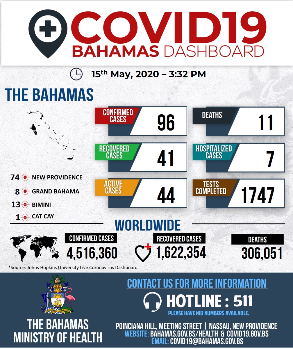
Just a brief update. The Bahamas continue to prohibit any visitors to the country, although some citizens and permanent residents have finally been allowed to return home if they agree to be quarantined for two weeks. The current order will expire at the end of May unless it is extended again. There have been a total of 96 confirmed cases of Covid-19 in the Bahamas and you can see the breakdown of status and location on the government dashboard here.
Bimini, where Division Belle is located, has become something of a hotspot for the virus. There have been 13 cases reported there among the roughly 2,000 residents, so the island is under a total lockdown. Bimini is very densely populated and it is difficult to maintain social distancing there.
Being optimistic, it might be possible for me to return to my boat by June 1, but if either of these two current orders are extended, the wait will be longer, and extend into the early part of hurricane season. I have a couple of possible ways to fly into Bimini directly from home by private plane whenever it is permitted, and my thinking is that I should go as quickly as possible to retrieve the boat in case travel restrictions are reimposed. We could distance ourselves when we arrive and go straight into self-quarantine on the boat until weather permits a departure to Florida.
Saturday, May 16, 2020
Still Stuck

 Thanks for reading the blog. We love to hear comments, so please click "Comments" just a few lines above this to leave one.
Saturday, April 4, 2020
Division Belle during Covid-19
I am acutely aware of the suffering of so many people all over the world during this pandemic. My heart goes out to those who are sick and to the untold millions of people in severe economic distress caused by this tragedy. We are doing fine and are very fortunate to live in a community that has battened down the hatches. Any small misstep can put many in danger, so I urge everyone to stay strong and in place.
As for Division Belle, she is still safely tied up at Brown's Marina in Bimini, and I am informed by the dock master that they are keeping an eye on her for me. She is still transmitting her AIS position regularly, and it shows up on the marinetraffic.com website like this:

The Bahamas have completely closed their borders to everyone, including their own citizens and residents who might be stuck elsewhere. There is no telling when it might be safe to travel again or when The Bahamas might begin to let people in. These islands are mostly quite poor and have very limited health care facilities. It took more than 24 hours to get one citizen of Bimini airlifted to a hospital in Nassau and she unfortunately passed away upon arrival. I wish nothing but the best for the gentle people of The Bahamas.
One final screenshot of the marinetraffic website. If you look carefully you can see eight Carnival cruise ships anchored together off the Bahamas, and numerous other cruise ships just aimlessly meandering between Florida and The Bahamas. One ship's AIS transmitter shows its destination as "drifting".

Stay safe everyone, and I'll check back in when there is something to report.
As for Division Belle, she is still safely tied up at Brown's Marina in Bimini, and I am informed by the dock master that they are keeping an eye on her for me. She is still transmitting her AIS position regularly, and it shows up on the marinetraffic.com website like this:

The Bahamas have completely closed their borders to everyone, including their own citizens and residents who might be stuck elsewhere. There is no telling when it might be safe to travel again or when The Bahamas might begin to let people in. These islands are mostly quite poor and have very limited health care facilities. It took more than 24 hours to get one citizen of Bimini airlifted to a hospital in Nassau and she unfortunately passed away upon arrival. I wish nothing but the best for the gentle people of The Bahamas.
One final screenshot of the marinetraffic website. If you look carefully you can see eight Carnival cruise ships anchored together off the Bahamas, and numerous other cruise ships just aimlessly meandering between Florida and The Bahamas. One ship's AIS transmitter shows its destination as "drifting".

Stay safe everyone, and I'll check back in when there is something to report.
Thanks for reading the blog. We love to hear comments, so please click "Comments" just a few lines above this to leave one.
Saturday, March 14, 2020
Coronavirus
It has become obvious now that the Coronavirus pandemic will affect our cruising plans on Division Belle. While being anchored out in the Bahamas is probably the safest place we could be, we had been planning to come and go from the boat while leaving it in the Exumas. From there, this would involve taking international flights and spending time in international airports, things that people my age have been advised not to do unnecessarily. On my trip home from Bimini a week ago, I took a small seaplane with seven passengers to Sheltair in Fort Lauderdale, the fixed based operator there for private planes. I then rented a car to drive home. I was well-equipped with hand sanitizer and Clorox wipes for the entire trip.
I'm not in any kind of panic, but I am trying to listen carefully to the expert advice that is given. It seems logical that social distancing now will slow the spread, so as not to overwhelm our medical facilities. I'm washing my hands frequently, bumping elbows instead of shaking hands, and reconsidering gatherings and air travel that are not necessary. It just makes sense. One article I just read recommends against almost any social contact such as having friends to dinner in your home.
I have said many times that I love being on the boat, no matter where it is. It is certainly not necessary to get to the Exumas this year, so I'm now focusing on how to get to Bimini to bring the boat back closer to home. If I can't get there next week, the boat may just sit where it is until I can safely travel. I'll be trying to figure it out over the next few days and watching the weather for a good time to start back. Here's hoping more travel restrictions are not enacted before I can get there.
I'm not in any kind of panic, but I am trying to listen carefully to the expert advice that is given. It seems logical that social distancing now will slow the spread, so as not to overwhelm our medical facilities. I'm washing my hands frequently, bumping elbows instead of shaking hands, and reconsidering gatherings and air travel that are not necessary. It just makes sense. One article I just read recommends against almost any social contact such as having friends to dinner in your home.
I have said many times that I love being on the boat, no matter where it is. It is certainly not necessary to get to the Exumas this year, so I'm now focusing on how to get to Bimini to bring the boat back closer to home. If I can't get there next week, the boat may just sit where it is until I can safely travel. I'll be trying to figure it out over the next few days and watching the weather for a good time to start back. Here's hoping more travel restrictions are not enacted before I can get there.
Thanks for reading the blog. We love to hear comments, so please click "Comments" just a few lines above this to leave one.
Friday, March 6, 2020
Bimini Update and Photos




I earlier mentioned that the Compleat Angler Hotel had burned down prior to my last visit in 2008. The ruins are still here with a couple of markers attesting to its history. It is sad that it was not rebuilt, as it was the place to go on Bimini for about 70 years. An awful lot of valuable memorabilia was lost in the fire, along with the life of its owner.
 |
| Ruins of the Compleat Angler Hotel |
 |
| Note the list of guests includes Senator Gary Hart. His famous photo with Donna Rice on the yacht Monkey Business was taken right here in Bimini. What happens in Bimini doesn't just stay in Bimini. |
 This being the Bahamas, it is not unusual to go to odd places to locate goods or services. Years ago in Georgetown, Exuma we inquired where we could purchase fresh fish or Bahamian lobster and were directed to a beauty shop. The owner's husband caught fish and she sold it out of coolers in the back room. Here in Bimini, if you need a propane tank filled, a couple of large tanks and trucks are parked under some trees at the very south end of the island. If the proprietor is there, you will see his white pickup truck. Otherwise he can be found at the liquor store across the street from Brown's marina. I got one of our tanks filled yesterday ($15 for a small two-pound tank).
While here, I have enjoyed catching up with Sean and Louise, owners of my previous boat Steel Magnolia, now named Vector. We both left Florida Wednesday, they from Miami and I from Fort Lauderdale, and we have ended up docked next to each other for a few days.
 |
| Division Belle and Vector crossing the Gulf Stream |

I will be cleaning up and packing today for my seaplane flight back to the states tomorrow. I hope to get back down here soon to resume travels in the Bahamas.
Thanks for reading the blog. We love to hear comments, so please click "Comments" just a few lines above this to leave one.
Wednesday, March 4, 2020
Brown's Marina, Bimini, Bahamas
We made it across the Gulf Stream today, but not without a good bit of rocking and rolling. When I awoke this morning, the weather for today had turned a little worse. Winds were mostly around 15 knots and seas were three to four feet with an occasional perhaps five foot wave. The problem was that we were heading almost directly into the waves and they had a short period, or time between waves. So it was something like riding a hobby horse for much of the day. Running against both wind and the strong Gulf Stream current, we were only doing around 5.5 knots most of the day instead of our usual seven to eight knots. We left our dock at 7:10 this morning and were finally docked here at 4:10 pm.
I spent the next hour filling out paperwork and going through the tedious process of going through customs and then immigration, both about a half mile walk away. I'll spend tomorrow figuring out details about leaving the boat here and getting back home for a while. I'll update the photo section a little if I can get decent internet access.
I spent the next hour filling out paperwork and going through the tedious process of going through customs and then immigration, both about a half mile walk away. I'll spend tomorrow figuring out details about leaving the boat here and getting back home for a while. I'll update the photo section a little if I can get decent internet access.
Thanks for reading the blog. We love to hear comments, so please click "Comments" just a few lines above this to leave one.
Monday, March 2, 2020
Islands in the Stream
Weather changes and plans change. The Lovely Laura Lee headed home today and I stayed with the boat because it looked like I might have a weather window to get to the Bahamas this week. I am planning to depart Wednesday morning to Bimini, the closest of the islands of the Bahamas. Seas are projected to be quite comfortable and we should make it across in about seven to eight hours depending on seas and the strength of the Gulf Stream current. I will be accompanied by a hired captain recommended by my old friend Joel Davidson who is a yacht broker here with Outer Reef Yachts https://www.outerreefyachts.com/bio-joeldavidson.cfm.
I first visited Bimini in the 1990's when The Compleat Angler Hotel was still standing. It was where Ernest Hemingway apparently lived and wrote in the 1930's when he was not staying on his boat in Bimini. The old bar in the downstairs of the hotel was thriving, and the walls were covered with Hemingway photos and memorobilia. This bar was the also site of the original ring toss game, where a ring is attached to a string hooked to the ceiling, and the object is to swing the ring and have it land on a hook attached to the wall. I credit my friend Chuck Butterworth with introducing this game to me well before I ever visited Bimini. You can still find kits of ring and string for sale called the "Bimini Ring Toss Game".
My last visit to Bimini was in 2008 with my friend James Abele (Perfect Deck Hand). Here is the blog entry from that visit on March 13, 2008 when we travelled from Chub Cay to Bimini:
In preparation for this visit, I have been re-reading Hemingway's "Islands in the Stream". In Part One of the book, entitled "Bimini", the main character, who resembles Hemingway himself, lives in a house that actually matches the description of the Compleat Angler Hotel. The hotel and bar are part of the story, but were called the "Ponce De Leon" in the book. I will again be docking at Brown's, mentioned in my old blog and the site of a great fistfight in Hemingway's book.
I'm excited to get back to Bimini, and I want to check out a few things. First, what I wrote of previously as "Bimini Bay" became "Resort World", and I will be interested to see how the resort has fared. Second, I want to return to the "End of the World Saloon", also known as the "Sand Bar" and see if it is still flourishing. It was a dive with Graffiti-covered walls, and the primary decor consisted of hundreds of pairs of women's underwear hanging from the walls and ceiling. There is just no telling what it is like today. And finally, I want to revisit the location of the Compleat Angler to see what, if anything, is left.
The weather has been terrible of late for crossing the Gulf Stream from Florida to the Bahamas. We have had one cold front after another for weeks, leaving few good "windows" for a crossing. Wednesday looks like a good one, but we shall see. I'm excited to get this boat out in the open ocean, because so far I have only had a few calm days at sea. I'll perhaps find out what needs to be better secured and what falls off the kitchen counter. I'll report back to let you know how the trip went.
I first visited Bimini in the 1990's when The Compleat Angler Hotel was still standing. It was where Ernest Hemingway apparently lived and wrote in the 1930's when he was not staying on his boat in Bimini. The old bar in the downstairs of the hotel was thriving, and the walls were covered with Hemingway photos and memorobilia. This bar was the also site of the original ring toss game, where a ring is attached to a string hooked to the ceiling, and the object is to swing the ring and have it land on a hook attached to the wall. I credit my friend Chuck Butterworth with introducing this game to me well before I ever visited Bimini. You can still find kits of ring and string for sale called the "Bimini Ring Toss Game".
My last visit to Bimini was in 2008 with my friend James Abele (Perfect Deck Hand). Here is the blog entry from that visit on March 13, 2008 when we travelled from Chub Cay to Bimini:
Yesterday, we departed early for the long run across the Banks to Bimini. We covered some 83 nautical miles and anchored just before dark on the east side of Bimini, as it was too close to dark to attempt coming around the island and into the harbor. We thought we had found a perfect anchorage off a beautiful beach but it became very rough when the wind moved around to northwest during the night and swells came around the island, hitting us from the north. The boat rolled and doors rattled, and our anchor dragged slightly. But we made it through the night. This morning, we came around into the harbor and tied up at Brown’s Hotel and Marina, right next to the famous “End of the World Bar”, which we’ll check out tonight.
Bimini has seen some improvement since last I was here. A gigantic development is going on at the north end of the island called “Bimini Bay”. We checked it out by golf cart today and it is going to be very nice. Unfortunately, the Compleat Angler Hotel, hangout of Earnest Hemingway, had a fire and may be gone for good. The outside walls are still standing but we don’t know if it will be salvaged or torn down. The remainder of Alicetown is still pretty run down, but there are signs of improvement, including the new docks at Brown’s where we are staying.
In preparation for this visit, I have been re-reading Hemingway's "Islands in the Stream". In Part One of the book, entitled "Bimini", the main character, who resembles Hemingway himself, lives in a house that actually matches the description of the Compleat Angler Hotel. The hotel and bar are part of the story, but were called the "Ponce De Leon" in the book. I will again be docking at Brown's, mentioned in my old blog and the site of a great fistfight in Hemingway's book.
I'm excited to get back to Bimini, and I want to check out a few things. First, what I wrote of previously as "Bimini Bay" became "Resort World", and I will be interested to see how the resort has fared. Second, I want to return to the "End of the World Saloon", also known as the "Sand Bar" and see if it is still flourishing. It was a dive with Graffiti-covered walls, and the primary decor consisted of hundreds of pairs of women's underwear hanging from the walls and ceiling. There is just no telling what it is like today. And finally, I want to revisit the location of the Compleat Angler to see what, if anything, is left.
The weather has been terrible of late for crossing the Gulf Stream from Florida to the Bahamas. We have had one cold front after another for weeks, leaving few good "windows" for a crossing. Wednesday looks like a good one, but we shall see. I'm excited to get this boat out in the open ocean, because so far I have only had a few calm days at sea. I'll perhaps find out what needs to be better secured and what falls off the kitchen counter. I'll report back to let you know how the trip went.
Thanks for reading the blog. We love to hear comments, so please click "Comments" just a few lines above this to leave one.
Saturday, February 29, 2020
Dania Beach
We are in Harbour Towne Marina in Dania Beach, Florida, just south of Fort Lauderdale. We have had a fun week, topped off by an incredible dinner last night at Valentino Cucina Italiana in Fort Lauderdale . While the weather has prevented crossing to Bimini, we have enjoyed our time on the boat.
Wednesday night we had the pleasure of dinner with our old friends Sean and Louise Welsh, who purchased our previous boat Steel Magnolia, now named Vector. (See www.ourodyssey.blogspot.com.) As always, I learn quite a bit from Sean and Louise, as they live full time on the boat and have become quite knowledgeable. And it's also just good to see them.
Tomorrow we plan to head back home for a little while, because it seems clear there is no good weather for getting to the Bahamas in the coming week. I'll be watching it closely and heading back this way when possible.
Wednesday night we had the pleasure of dinner with our old friends Sean and Louise Welsh, who purchased our previous boat Steel Magnolia, now named Vector. (See www.ourodyssey.blogspot.com.) As always, I learn quite a bit from Sean and Louise, as they live full time on the boat and have become quite knowledgeable. And it's also just good to see them.
Tomorrow we plan to head back home for a little while, because it seems clear there is no good weather for getting to the Bahamas in the coming week. I'll be watching it closely and heading back this way when possible.
Thanks for reading the blog. We love to hear comments, so please click "Comments" just a few lines above this to leave one.
Wednesday, February 26, 2020
Mega Yachts
We are in Fort Lauderdale this evening, in the world of Mega Yachts, and in a marina where a boat slip costs more than a decent hotel room for the night. The yachts we have seen are simply stunning. Last night we spent the night in Jupiter, Florida, just a few slips down from "Privacy", Tiger Woods' yacht.
Tiger's yacht seems downright small compared to the boat tied up at the end of our dock. It is named "MLR" and was built by Delta Marine of Seattle. It is 53 meters in length, around 174 feet. While my boat's displacement is roughly 50 tons, MLR's is 955 tons. We use one 50-amp shore cord in marinas, but this yacht appears to be connected to three 100-amp cords.


I have searched high and low on the internet and I cannot determine her owner, but I ran across one interesting tidbit. According to the yacht's designer, MLR stands for a "Momentary Lapse of Reason". This makes it the only boat I have heard of other than ours that is named after a Pink Floyd album.
It is unlikely that we will be able to cross the Gulf Stream to the Bahamas tomorrow. The wind just won't quit. The offshore forecast calls for seas of four to six feet, more than we wish to handle. My magical PredictWind app shows four-foot seas under all of its three models but shows the wave period, or time between waves, as only 4.5 seconds. So these are not gentle four-foot swells eight or 10 seconds apart but steep four-foot waves that would slam us up and down. Interestingly, my forecaster Chris Parker shows that a messy eastbound crossing might be available Friday or Sunday. We'll see, and will continue to watch and keep you posted.
 |
| Tiger Woods' Yacht |


 |
| MLR |
It is unlikely that we will be able to cross the Gulf Stream to the Bahamas tomorrow. The wind just won't quit. The offshore forecast calls for seas of four to six feet, more than we wish to handle. My magical PredictWind app shows four-foot seas under all of its three models but shows the wave period, or time between waves, as only 4.5 seconds. So these are not gentle four-foot swells eight or 10 seconds apart but steep four-foot waves that would slam us up and down. Interestingly, my forecaster Chris Parker shows that a messy eastbound crossing might be available Friday or Sunday. We'll see, and will continue to watch and keep you posted.
Thanks for reading the blog. We love to hear comments, so please click "Comments" just a few lines above this to leave one.
Saturday, February 22, 2020
Watching the Weather
 |
| Front After Front |
Normally when a cold front passes, the winds clock around from south to west to north, and the north winds are cold and strong for two or three days thereafter. That is exactly what happened here when the front passed last night with heavy rain and we awoke this morning to strong cold winds from a northerly direction. Strong north winds blowing against the Gulf Stream current make waves stand up and get very steep, and uncomfortable. So the usual practice is to wait a few days after the front and dash across the Gulf Stream before the next front arrives. The problem for quite awhile this winter is that the next front arrives before the winds ever settle down from the previous one.
The best advice I ever got about crossing the Gulf Stream was from a book entitled A Gentleman's Guide to Passages South by Bruce Van Sant. He said simply: "Under prevailing conditions, wait until the Offshore Forecast says south of east winds of less than 15 knots and seas less than three feet." He was speaking more of comfort than safety. Our boat can handle much rougher seas than I can. But in fact, under the current forecast for Wednesday, we should have southeast to south winds 10 to 15 knots and seas of two to four feet, pretty close to what he advised as the maximum.
There are two problems though. This is Saturday and a lot can change by Wednesday. And second, there are today many more models and forecasts than the National Weather Service Offshore Forecast, and they are not all in agreement. For Wednesday, Chris Parker's Marine Weather Center says: "Brisk SSE-S wind prevents comfortable travel Tue25, then very brisk S-SSW wind keeps travel window closed Wed26." PredictWind, an app I study regularly, calls for 2.5-foot waves Wednesday at noon between Fort Lauderdale and Bimini, but predicts winds of 19 knots. Using PredictWind's second model, it predicts similar seas but winds of only 13 knots. Its Euro model has winds at 19 knots and seas of 4.2 feet.
Too much information I think, but I have been watching it obsessively for the last few days. It does show that we are on the margins. The answer will not come until Tuesday night or early Wednesday morning when we can see what the sea buoys tell us about wind and seas, and see if the forecasts for the day have come more into agreement. If we can't go this time, we wait for the next front to pass and try again.
I'll keep you posted. The good news is that I am happy to be on the boat, no matter where it is. We will eventually get there.
Thanks for reading the blog. We love to hear comments, so please click "Comments" just a few lines above this to leave one.
Friday, February 7, 2020
Georgia's Controversial Anchoring Regulation
Every time I depart by boat from The Ford Plantation heading south, there are several lovely spots to anchor overnight along the Intracoastal Waterway (ICW) or close to various inlets if I am at sea in decent weather. I have spent many great evenings along this route. Unfortunately, it is now illegal to anchor in many of my favorite spots because of a new Georgia law and a regulation that has been issued in its wake. Georgia now has the most restrictive anchoring regulations in the nation. The regulation impacted 62% of anchorages along the ICW and eliminated 39% of them altogether. Here are anchorages near the ICW in the Sapelo Island area (red eliminated, yellow impacted):
 |
| Red Anchorages Eliminated, Yellow Impacted, Green Still Usable |
The law is now codified as Section 52-7-8.4 of the Georgia Code. Oddly, the Act is premised on the prevention of sewage discharge from live-aboard boats in inland waters, something that has been illegal under the Clean Water Act at least since 1972. It is estimated that 90% of boaters fully comply with the federal law, and it is a fact that boaters care more than most about water quality and preventing pollution. Nevertheless, the statute starts off as follows:
52-7-8.4.
(a) The General Assembly finds that, because of the frequency of live-aboard vessels utilizing the estuarine areas of this state, it is necessary for the protection of the public health, safety, and welfare to prohibit the discharge of sewage from such vessels into estuarine areas of this state. It is declared to be the intent of the General Assembly to protect and enhance the quality of the waters of such estuarine areas by requiring greater environmental protection than is provided pursuant to Section 312 of the federal Water Pollution Control Act, as amended, such that any discharge of sewage from a live-aboard vessel into the waters of such estuarine areas shall be prohibited. [Nothing new here.]
The act goes on to clarify that sewage cannot be dumped overboard in Georgia waters, making something illegal that was already illegal, and seems to require that any valve that allows sewage to go overboard or be pumped overboard must be "secured". It says "Examples of secured mechanisms considered to be effective at preventing discharges include, but are not limited to, closing the seacock and padlocking, using a non-releasable wire tie, or removing the seacock handle with the seacock in the closed position." So now the valves on my boat that would permit direct discharge or pumping sewage overboard are secured with wire ties or have the handle removed. I'm also required to keep records of when and where I pump out sewage at a marina pump-out station.
Securing valves with plastic wire ties that can be cut with scissors or removed handles that can be replaced seems a little silly, and targeting pleasure boats is outrageous in light of the problem of sewage plants that overflow and dump raw sewage every day in Georgia. The Georgia Environmental Protection Division keeps a running 30-day tally of these spills on its website. If there is a measurement of the amount of the spill, the total gallons is shown. As of yesterday, for the last 30 days, 582,689 gallons of raw sewage has been reported as flowing into our creeks and rivers. Many spills are not measurable and no doubt the total amount is much higher. In December, Valdosta, GA had a spill of 7.5 million gallons of raw sewage that overflowed for several days into the woods, into a creek, and then into a river that flows down into Florida. But OK, even though I'm not part of the problem, I don't mind wire-tying my sewage valves and I don't mind complying with what was already federal law.
This screenshot below illustrates the odd rule. It shows Kilkenny Creek Marina where there is no anchoring within 300 feet (red), the (blue) permitted zone from 300 to 1,000 feet from the marina, and then the no anchoring zone beyond (pink) because there are structures within 1,000 feet. To go to dinner at Marker 107 Restaurant, it would be a balancing act to be sure you are in one of the little blue zones.
 |
| Kilkenny Creek Marina and Marker 107 Restaurant |
Another chart shows the areas near Thunderbolt and Isle of Hope in Savannah where anchoring is forbidden (in pink). Part of the problem is that the DNR has published these maps but states that you may not rely on them. So it is difficult in many cases to figure out where you can be overnight.
 |
| Thunderbolt/Isle of Hope Area |
Finally, just in the last few days, Boat US, the largest organization of boaters, has issued a "call to action" to lobby the governor and state legislature to intervene. As the organization said:
This 1,000-foot offset needlessly eliminates anchorages all over the state. It will affect numerous boaters, many of whom transit Georgia waters as part of the annual migration along the Intracoastal Waterway (ICW) that brings in millions of dollars to Georgia businesses. There is no reasonable safety or waterway-management reason for taking such a significant swath of state waters from the boating public.
Curiously, DNR did create so-called “Marina Zones” that allow boaters to anchor as close as 300 feet to marinas or facilities that provide fuel, dinghy access, provisions, vessel maintenance or other services, regardless of whether other structures exist nearby. This can only lead to the conclusion that the reason for the greater offset from private structures outside these zones was to provide waterfront landowners with near exclusive use and enjoyment of our shared waterways.
Boat U.S. recognizes the need for states to manage their waterways and supports reasonable regulations that protect the public’s access. The ability of anchor overnight is an important part of how many boaters choose to enjoy the water. Please send a message today asking to repeal this rule.
The strangest thing about this all is that a law that was premised on stopping pollution from sewage discharge has morphed into complex rules about where one can anchor. Where a boat anchors has nothing to do with sewage, which cannot be legally discharged anywhere in the inland waters of Georgia, whether the boat is anchored or not. This regulation may have something to do with protecting land owners who don't want anyone anchoring in their back yard. Of course they don't own the water, but this regulation in effect grants it to them by saying any dock or piling can keep every boat from anchoring unless it is more than 1,000 feet away.
We have anchored fairly close to houses overnight on occasion, but we are quiet and respectful of our neighbors when we do so. This regulation has gone far beyond its intention of stopping the dumping of sewage. There are still a few spots to anchor, but some of the prime ones are gone. Here's hoping the political efforts are successful in bringing more balance to this regulation. We're happy to protect clean water and be good neighbors where we anchor, but this is just a strange and screwed up law and regulation.
UPDATE: House Bill 833 has been introduced in the Georgia House of Representatives that would negate some of the worst provisions of the current law and regulation. See http://www.legis.ga.gov/Legislation/20192020/188593.pdf.
UPDATE: House Bill 833 has been introduced in the Georgia House of Representatives that would negate some of the worst provisions of the current law and regulation. See http://www.legis.ga.gov/Legislation/20192020/188593.pdf.
Thanks for reading the blog. We love to hear comments, so please click "Comments" just a few lines above this to leave one.
Wednesday, January 29, 2020
Regrouping
I am in Stuart, Florida tonight where I have rented a slip for up to a month to regroup before attempting a crossing to the Bahamas. The Lovely Laura Lee rented a car today in Fort Pierce and headed home for her work, and to care for our two precious dogs. I will work on a few projects on the boat and probably return home by Friday. For stays of more than about eight days, it is cheaper to get a slip for the monthly rate to give us time to figure out next steps.
Fortunately, I recalled this week that I had never purchased add-on coverage for boat insurance to cover the Bahamas. I logged on this afternoon and added the coverage at a minimal cost, so we are ready to go.
Internet access has been a problem for us this last week. We have a hotspot with an external antenna on the boat, and while it is part of our "unlimited" data plan with Verizon, it reached the limit where our speed was "throttled" so that nothing worked well. We have a smart TV, laptops, phones, and iPads all using data, so we are learning that we need to make other arrangements. I have found what I think is the only U.S. company offering totally unlimited, un-throttled data and we will get a SIM card from them shortly for our boat hotspot. The company is called finallywifi.com and the service is available using the AT&T network for $110 a month. We are addicted, so it is worth it. They have a sister company called My Island WiFi that we plan to use in the Bahamas while we are there.
The weather for crossings of the Gulf Stream to Bimini has been terrible, although probably typical for January. The forecaster I follow had the following to say today:
SYNOPSIS:
TODAY: Frontal TROF along with remnant IMPULSE energy enters Grand Bahama/Abaco this morning, then arrives in Nassau-Eleuthera around midday with W<N wind as the TROF passes. Squalls are found along and ahead of the TROF. Areas in SE Bahamas have very little wind today, mostly from S<W. N<NE-E wind settles tonight along FL and NW-C Bahamas as Frontal TROF mostly stalls in C Bahamas and weakens.
WED29: Another IMPULSE of energy develops in N GOMEX Wed29, surging SE-S wind along FL. The NW & C Bahamas see building of E<S wind Wed29 afternoon-evening, while the rest of the Bahamas remain very mild. The IMPULSE or LO likely exits NFL Wed29 night (between sunset and midnight) with variable wind and squalls...squalls also develop ahead of the IMPULSE Wed29 in areas of warm, moist S flow.
THU30: The IMPULSE rapidly moves E along 30N Thu30, trailing a ColdFRONT thru SFL and the NW Bahamas Thu30 morning. This initial FRONT veers mostly S wind to W-NW before slowing across the S-C Bahamas Thu30 night. Meanwhile, a second FRONT is along NFL Thu30 morning with brisk NE wind. This second FRONT has uncertain implications, but there is the potential for the FRONT to provide stiff NE<E wind for some of the FL Coast. The location of this FRONT and the strength of the wind in the region is dependent on the next developing system...a brief moderation of all wind is possible (around late Thu30) before flow increases into the next system.
FRI31-SAT1: A messy and disorganized area of low pressure develops in the N GOMEX Fri31, dominating the wind pattern. The main piece of energy likely lifts NE thru the FL Panhandle before either riding along the SE US or ejecting offshore. In either case, it appears likely that the Bahamas/FL see a strong ColdFRONT and perhaps an area of tightening low pressure along the frontal boundary. Forecast details cannot be determined with confidence this far in advance, but it appears likely that the most inclement conditions along FL are late Fri31 into early Sat1 before the FRONT pushes into the NW and N-C Bahamas by the end of the day Sat1. Very brisk winds may accompany the initial FRONT or behind a secondary FRONT late Sat1.
This whole messy winter weather pattern gives us a good reason to regroup before attempting further travel.
Fortunately, I recalled this week that I had never purchased add-on coverage for boat insurance to cover the Bahamas. I logged on this afternoon and added the coverage at a minimal cost, so we are ready to go.
Internet access has been a problem for us this last week. We have a hotspot with an external antenna on the boat, and while it is part of our "unlimited" data plan with Verizon, it reached the limit where our speed was "throttled" so that nothing worked well. We have a smart TV, laptops, phones, and iPads all using data, so we are learning that we need to make other arrangements. I have found what I think is the only U.S. company offering totally unlimited, un-throttled data and we will get a SIM card from them shortly for our boat hotspot. The company is called finallywifi.com and the service is available using the AT&T network for $110 a month. We are addicted, so it is worth it. They have a sister company called My Island WiFi that we plan to use in the Bahamas while we are there.
The weather for crossings of the Gulf Stream to Bimini has been terrible, although probably typical for January. The forecaster I follow had the following to say today:
SYNOPSIS:
TODAY: Frontal TROF along with remnant IMPULSE energy enters Grand Bahama/Abaco this morning, then arrives in Nassau-Eleuthera around midday with W<N wind as the TROF passes. Squalls are found along and ahead of the TROF. Areas in SE Bahamas have very little wind today, mostly from S<W. N<NE-E wind settles tonight along FL and NW-C Bahamas as Frontal TROF mostly stalls in C Bahamas and weakens.
WED29: Another IMPULSE of energy develops in N GOMEX Wed29, surging SE-S wind along FL. The NW & C Bahamas see building of E<S wind Wed29 afternoon-evening, while the rest of the Bahamas remain very mild. The IMPULSE or LO likely exits NFL Wed29 night (between sunset and midnight) with variable wind and squalls...squalls also develop ahead of the IMPULSE Wed29 in areas of warm, moist S flow.
THU30: The IMPULSE rapidly moves E along 30N Thu30, trailing a ColdFRONT thru SFL and the NW Bahamas Thu30 morning. This initial FRONT veers mostly S wind to W-NW before slowing across the S-C Bahamas Thu30 night. Meanwhile, a second FRONT is along NFL Thu30 morning with brisk NE wind. This second FRONT has uncertain implications, but there is the potential for the FRONT to provide stiff NE<E wind for some of the FL Coast. The location of this FRONT and the strength of the wind in the region is dependent on the next developing system...a brief moderation of all wind is possible (around late Thu30) before flow increases into the next system.
FRI31-SAT1: A messy and disorganized area of low pressure develops in the N GOMEX Fri31, dominating the wind pattern. The main piece of energy likely lifts NE thru the FL Panhandle before either riding along the SE US or ejecting offshore. In either case, it appears likely that the Bahamas/FL see a strong ColdFRONT and perhaps an area of tightening low pressure along the frontal boundary. Forecast details cannot be determined with confidence this far in advance, but it appears likely that the most inclement conditions along FL are late Fri31 into early Sat1 before the FRONT pushes into the NW and N-C Bahamas by the end of the day Sat1. Very brisk winds may accompany the initial FRONT or behind a secondary FRONT late Sat1.
This whole messy winter weather pattern gives us a good reason to regroup before attempting further travel.
Thanks for reading the blog. We love to hear comments, so please click "Comments" just a few lines above this to leave one.
Monday, January 27, 2020
Fort Pierce
We spent last night in Cocoa, Florida, to be distinguished from Cocoa Beach, which is across the bridge on the barrier island. Yesterday we travelled 58 nautical miles in the Intracoastal Waterway (ICW) in eight hours. We averaged only 7.25 knots because the current was against us a part of the day, and because we traversed several long areas where we slowed because depths were only seven to eight feet, close to dragging the bottom in our six-foot-draft boat.
We were in sight much of yesterday afternoon of Elon Musk's SPACEX Falcon 9 rocket at Cape Canaveral, poised for the launch of Starlink's third mission to fill the heavens with little satellite hotspots designed to bring the internet to the whole world from space. The launch was scheduled for 9:49 am this morning, but was postponed until tomorrow morning. We were at the perfect vantage point, but we shall miss the view now.
We are underway and due into Fort Pierce in about an hour and a half. I have been hoping to get the boat within striking distance of Fort Lauderdale and await a weather window to cross over to the Bahamas. Alas, as of now, the weather is not cooperating. For a day to cross to the Bahamas, I need two things. First, there must be no northerly component to the winds. Winds from the north run into the Gulfstream current and make the waves stand up in a very uncomfortable way. Second, I need fairly calm seas and winds under 15 knots. Neither of these conditions seem on the forecast for a full day or night in the next week. We've had a series of frontal passages the just won't quit. I have heard stories of fishing boats moved to the Bahamas that have not been able to go out since mid December.
In addition to correct winds and seas, I need somebody to accompany me. So the plan today was to leave the boat in Fort Pierce for a few weeks and head home. Calling around today I had no luck finding dockage for the next few weeks, and barely found a slip just for tonight. LL will head home tomorrow and I'll keep checking for dockage further south, perhaps in Stuart.
We found good chile at a local joint last night, but there were no other real choices on a Sunday night in Cocoa. Tonight we will be dining in.
Whatever the weather or final outcome tomorrow for docking, this has been a great week on the boat. While I prefer going outside in the ocean, I have enjoyed having the Lovely Laura Lee along and just spending time on the water. We'll report back next steps in the next day or two.
Update: We arrived safely in Fort Pierce. The Lovely Laura Lee has a car reserved tomorrow to return home. I found dockage in Stuart, Florida, just a few hours to the south. I will spend a few days with boat projects and then come home to regroup and plan to head out to the Bahamas.
P27, 2020 09:49 AM | SPACEX FALCON 9 STARLINK 3RD MISSION JAN 27, 2020 09:49 AM | SPACEX FALCON 9 STARLINK 3RD MISSION
We were in sight much of yesterday afternoon of Elon Musk's SPACEX Falcon 9 rocket at Cape Canaveral, poised for the launch of Starlink's third mission to fill the heavens with little satellite hotspots designed to bring the internet to the whole world from space. The launch was scheduled for 9:49 am this morning, but was postponed until tomorrow morning. We were at the perfect vantage point, but we shall miss the view now.
We are underway and due into Fort Pierce in about an hour and a half. I have been hoping to get the boat within striking distance of Fort Lauderdale and await a weather window to cross over to the Bahamas. Alas, as of now, the weather is not cooperating. For a day to cross to the Bahamas, I need two things. First, there must be no northerly component to the winds. Winds from the north run into the Gulfstream current and make the waves stand up in a very uncomfortable way. Second, I need fairly calm seas and winds under 15 knots. Neither of these conditions seem on the forecast for a full day or night in the next week. We've had a series of frontal passages the just won't quit. I have heard stories of fishing boats moved to the Bahamas that have not been able to go out since mid December.
In addition to correct winds and seas, I need somebody to accompany me. So the plan today was to leave the boat in Fort Pierce for a few weeks and head home. Calling around today I had no luck finding dockage for the next few weeks, and barely found a slip just for tonight. LL will head home tomorrow and I'll keep checking for dockage further south, perhaps in Stuart.
We found good chile at a local joint last night, but there were no other real choices on a Sunday night in Cocoa. Tonight we will be dining in.
Whatever the weather or final outcome tomorrow for docking, this has been a great week on the boat. While I prefer going outside in the ocean, I have enjoyed having the Lovely Laura Lee along and just spending time on the water. We'll report back next steps in the next day or two.
Update: We arrived safely in Fort Pierce. The Lovely Laura Lee has a car reserved tomorrow to return home. I found dockage in Stuart, Florida, just a few hours to the south. I will spend a few days with boat projects and then come home to regroup and plan to head out to the Bahamas.
P27, 2020 09:49 AM | SPACEX FALCON 9 STARLINK 3RD MISSION JAN 27, 2020 09:49 AM | SPACEX FALCON 9 STARLINK 3RD MISSION
Thanks for reading the blog. We love to hear comments, so please click "Comments" just a few lines above this to leave one.
Saturday, January 25, 2020
Daytona Beach
I am not one to plan my travels based on favorable currents, although I do try to avoid shallow areas at low tide. With currents, I figure I will go slower or faster because of currents in about a 50-50 ratio, and life will work out as it does. But today we got lucky and had helpful currents the entire way. We covered 50 nautical miles in six hours, averaging about 8.3 knots speed over ground, even though our best speed through the water was 8 knots, and we slowed many times for traffic, bridges, no-wake zones, and shallow areas. We celebrated by stopping at 3 pm in Daytona Beach and took a walk through the old downtown area. It was a spectacularly beautiful day.
We finally got away from the Lamb's Yacht Center boatyard yesterday morning. We had planned on departing Thursday, but our stern thruster batteries failed while moving the boat Wednesday afternoon (the batteries not only were both dead, but one of them blew a hole in its side, smoking and dripping battery acid inside its box). The service guys at Lamb's were great: they located batteries locally Thursday morning and had them installed that afternoon. Not an easy job removing and replacing 150-pound batteries in the cramped lazarette area under the aft deck. Departing at around 8 am yesterday, we made it to St. Augustine and on to Daytona Beach today.
We've been watching the ocean, Seas are finally coming down to four feet in our area tomorrow, but we couldn't leave from Ponce De Leon inlet tomorrow without committing to an overnight passage around Cape Canaveral, and neither of us are interested in doing that without a third hand on board. Our next option will be Monday to exit into the ocean at Cape Canaveral and go direct to Fort Pierce. Seas in that area Monday are expected to be very calm, so we will consider tomorrow turning off the ICW to head over to Port Canaveral and making an outside run Monday. We'll see how the schedule goes tomorrow, and we note there is a rocket launch scheduled for Monday morning at 9:49 am from Cape Canaveral. We will enjoy seeing it, but we need to find out if any areas of the inlet or the ocean will be blocked to marine traffic. Wherever we end up Monday night, the lovely Laura Lee needs to head back home Tuesday, probably by rental car. If there is a chance I can get a weather window to cross to the Bahamas soon, and a crew member to help. I'll stay with the boat and plan a crossing. If the weather looks bad for a crossing soon, I will probably return home with LL and await the next opportunity.
While all of this is up in the air, we really don't care where we get when, and we are having a delightful cruise. We are snug tonight at Halifax Harbor Marina with LL cooking up a delightful dinner. On the back deck, I can hear the sounds of the Rolex 24-hour race at Daytona International Speedway just three miles away. It started this afternoon and will last, well, 24 hours.
We'll post updates as we go.
We finally got away from the Lamb's Yacht Center boatyard yesterday morning. We had planned on departing Thursday, but our stern thruster batteries failed while moving the boat Wednesday afternoon (the batteries not only were both dead, but one of them blew a hole in its side, smoking and dripping battery acid inside its box). The service guys at Lamb's were great: they located batteries locally Thursday morning and had them installed that afternoon. Not an easy job removing and replacing 150-pound batteries in the cramped lazarette area under the aft deck. Departing at around 8 am yesterday, we made it to St. Augustine and on to Daytona Beach today.
We've been watching the ocean, Seas are finally coming down to four feet in our area tomorrow, but we couldn't leave from Ponce De Leon inlet tomorrow without committing to an overnight passage around Cape Canaveral, and neither of us are interested in doing that without a third hand on board. Our next option will be Monday to exit into the ocean at Cape Canaveral and go direct to Fort Pierce. Seas in that area Monday are expected to be very calm, so we will consider tomorrow turning off the ICW to head over to Port Canaveral and making an outside run Monday. We'll see how the schedule goes tomorrow, and we note there is a rocket launch scheduled for Monday morning at 9:49 am from Cape Canaveral. We will enjoy seeing it, but we need to find out if any areas of the inlet or the ocean will be blocked to marine traffic. Wherever we end up Monday night, the lovely Laura Lee needs to head back home Tuesday, probably by rental car. If there is a chance I can get a weather window to cross to the Bahamas soon, and a crew member to help. I'll stay with the boat and plan a crossing. If the weather looks bad for a crossing soon, I will probably return home with LL and await the next opportunity.
While all of this is up in the air, we really don't care where we get when, and we are having a delightful cruise. We are snug tonight at Halifax Harbor Marina with LL cooking up a delightful dinner. On the back deck, I can hear the sounds of the Rolex 24-hour race at Daytona International Speedway just three miles away. It started this afternoon and will last, well, 24 hours.
We'll post updates as we go.
Thanks for reading the blog. We love to hear comments, so please click "Comments" just a few lines above this to leave one.
Thursday, January 23, 2020
Ready to leave (and some weather)
We had our stern thruster batteries replaced today, so we should finally get away tomorrow morning. However, the weather continues to present one cold front after another, forcing us to stay inside the Intracoastal Waterway. The current weather map shows one front now down near Cuba with the one that passed through this week now in south Florida and two more on the way.

But at least we are not in Spain or Mallorca where they have had waves taller than buildings (Click for the YouTube video).

But at least we are not in Spain or Mallorca where they have had waves taller than buildings (Click for the YouTube video).
Thanks for reading the blog. We love to hear comments, so please click "Comments" just a few lines above this to leave one.
Wednesday, January 22, 2020
Travel Update
I stopped in Jacksonville, Florida 10 days ago to leave the boat for repair of a clogged toilet (a constant in the glamorous world of yachting), and to replace a 300-foot anchor chain that was hopelessly rusted. The toilet is working fine but the anchor chain arrived Friday and was the wrong size for the sprocket on our anchor windlass. The chain was re-ordered from a different source in Fort Lauderdale and was to arrive yesterday. So I came back to Jacksonville yesterday with the Lovely Laura Lee in hopes of departing this morning. Alas, the chain did not get here so we are now hoping it will arrive today to allow us to get away tomorrow morning.
Not only the chain delay, but terrible winter weather is complicating our plans. Temperatures have dropped to around freezing for the last two mornings and it is 34 degrees as I write this. Winds and seas have been high with a Gale Warning in this area of the Atlantic last night. A gale is defined as 34–47 knots (39–54 miles/hour) of sustained surface winds. Winds this morning in the Atlantic are 26-29 knots with gusts to 32 knots and seas at 11 feet. This does not look to improve much this week, forcing us to plan travel in the Intracoastal Waterway (ICW). The ICW can be treacherous as there are many areas that have shoaled and it takes serious attention to drive all day and avoid running aground. Without going offshore, it could take us a week or more to get from Jacksonville to Fort Lauderdale where we could cross over to Bimini in the Bahamas.
It was seven years ago next week that I sold my last boat, and a lot of technology has changed in the world of boating, particularly with apps available for phones and tablets. They have become indispensable and I am only now beginning to understand the information that is out there. Most apps are available for both Apple and Android tablets and phones, but the Apple iOS products tend to get introduced and upgraded first. For the ICW, there is one App I have come to rely on that presents information that was just not available during my previous boating career. It is called Aqua Map.
Using Aqua Map, it was easy to download a safe track recently published by Robert Sherer, author of a book on traveling the ICW and administrator of a Facebook group called ICW Cruising Guide by Bob423. Aqua Map also displays Corps of Engineers depth surveys where they are available, and it downloads the entire Waterway Guide to marinas and user comments available on an app I also use called Active Captain. Below is the Aqua Map display of the entrance to the ICW going south from the St. Johns River in Jacksonville. The red, green and yellow portions are recent survey depths from the Corps of Engineers, while the blue dotted line is Bob's recent track. This kind of information takes much of the guesswork out of getting through the ICW.

Once we start planning to get out in the ocean and need wind and wave heights, I have come to rely on PredictWind. It provides 7-day forecasts that include wind, wave heights, and wave period (time in seconds between waves). Here are screenshots of the PredictWind wave map and a typical forecast captured several days back.


I also use two tide forecast apps, mostly just on my phone. One is called Tides Near Me which tells you tides in order of distance from your location, and the other is simply called "Tides". They both give the same official information presented slightly differently.
There are many more apps that I use on occasion. "MarineTraffic" allows you to look up the location of any ship or boat equipped with an AIS transponder. Two apps named "Snag-a-Slip" and "Dockwa" are for making marina reservations online. The Waterway Guide app gives full marina information. I have downloaded another app called "Logbook Suite", but I have resisted using it because I keep a logbook on an Excel spreadsheet, where I have the flexibility to do it as I please.
There appear to be hundreds more shown on the app store under the general headings of boating, yachting, navigation, weather, etc., but for the moment, I'll just continue to try to figure out all of the features of what I have. It's a new world.
We'll keep you posted when we finally get away headed south.
Wednesday Night Update: The chain got installed today and we moved the boat to an outer dock to prepare for an early departure tomorrow morning. In the process, in strong winds, the batteries for the stern thruster failed, leaving the lazarette area full of smoke and smelling of battery acid. Sigh... The electrical guy will look at it in the morning, but it is likely we will need new batteries. We just replaced the bow thruster batteries last month so it makes sense that the stern thruster batteries were due to fail. The only good news is that the best place for such a failure is in a boatyard, and especially not in the Bahamas where replacement would be much more expensive.
Not only the chain delay, but terrible winter weather is complicating our plans. Temperatures have dropped to around freezing for the last two mornings and it is 34 degrees as I write this. Winds and seas have been high with a Gale Warning in this area of the Atlantic last night. A gale is defined as 34–47 knots (39–54 miles/hour) of sustained surface winds. Winds this morning in the Atlantic are 26-29 knots with gusts to 32 knots and seas at 11 feet. This does not look to improve much this week, forcing us to plan travel in the Intracoastal Waterway (ICW). The ICW can be treacherous as there are many areas that have shoaled and it takes serious attention to drive all day and avoid running aground. Without going offshore, it could take us a week or more to get from Jacksonville to Fort Lauderdale where we could cross over to Bimini in the Bahamas.
It was seven years ago next week that I sold my last boat, and a lot of technology has changed in the world of boating, particularly with apps available for phones and tablets. They have become indispensable and I am only now beginning to understand the information that is out there. Most apps are available for both Apple and Android tablets and phones, but the Apple iOS products tend to get introduced and upgraded first. For the ICW, there is one App I have come to rely on that presents information that was just not available during my previous boating career. It is called Aqua Map.
Using Aqua Map, it was easy to download a safe track recently published by Robert Sherer, author of a book on traveling the ICW and administrator of a Facebook group called ICW Cruising Guide by Bob423. Aqua Map also displays Corps of Engineers depth surveys where they are available, and it downloads the entire Waterway Guide to marinas and user comments available on an app I also use called Active Captain. Below is the Aqua Map display of the entrance to the ICW going south from the St. Johns River in Jacksonville. The red, green and yellow portions are recent survey depths from the Corps of Engineers, while the blue dotted line is Bob's recent track. This kind of information takes much of the guesswork out of getting through the ICW.

Once we start planning to get out in the ocean and need wind and wave heights, I have come to rely on PredictWind. It provides 7-day forecasts that include wind, wave heights, and wave period (time in seconds between waves). Here are screenshots of the PredictWind wave map and a typical forecast captured several days back.


I also use two tide forecast apps, mostly just on my phone. One is called Tides Near Me which tells you tides in order of distance from your location, and the other is simply called "Tides". They both give the same official information presented slightly differently.
There are many more apps that I use on occasion. "MarineTraffic" allows you to look up the location of any ship or boat equipped with an AIS transponder. Two apps named "Snag-a-Slip" and "Dockwa" are for making marina reservations online. The Waterway Guide app gives full marina information. I have downloaded another app called "Logbook Suite", but I have resisted using it because I keep a logbook on an Excel spreadsheet, where I have the flexibility to do it as I please.
There appear to be hundreds more shown on the app store under the general headings of boating, yachting, navigation, weather, etc., but for the moment, I'll just continue to try to figure out all of the features of what I have. It's a new world.
We'll keep you posted when we finally get away headed south.
Wednesday Night Update: The chain got installed today and we moved the boat to an outer dock to prepare for an early departure tomorrow morning. In the process, in strong winds, the batteries for the stern thruster failed, leaving the lazarette area full of smoke and smelling of battery acid. Sigh... The electrical guy will look at it in the morning, but it is likely we will need new batteries. We just replaced the bow thruster batteries last month so it makes sense that the stern thruster batteries were due to fail. The only good news is that the best place for such a failure is in a boatyard, and especially not in the Bahamas where replacement would be much more expensive.
Thanks for reading the blog. We love to hear comments, so please click "Comments" just a few lines above this to leave one.
Tuesday, January 14, 2020
True Virgins Make Dull Company, Add Whiskey
For the navigation nerds out there like me, the ever-changing location of the magnetic North Pole is a matter of fascination, and everyday use. I can well remember that when I learned to fly, the long runway in Birmingham, Alabama was Runway 5/23. Adding a zero to the numbers told you that whenever you landed from the west your heading was something close to 50 degrees and from the east, your heading was close to 230 degrees. Years later, the runways were renumbered to 6/24 because the magnetic variation at Birmingham had changed a few degrees, so you were landing at a heading closer to 60 degrees or 240 degrees.
Those of us who have learned to navigate, by plane or by boat, have always had to deal with adjusting compass headings to make them correct. Admittedly, the advent of LORAN and then GPS navigation have decreased the importance of the magnetic compass, by letting us tell the autopilot to take us to a certain latitude and longitude, but the compass is still front and center in airplanes and boats to determine the course we are following. Nowadays, you can purchase a GPS compass that automatically does all of this for you.
Deviation is simply the error in one’s own compass caused by its construction or nearby magnetic fields in the cockpit or pilothouse. In a boat or airplane, a compass is “swung” by mysterious experts who produce a “compass card” of how to adjust your course at various headings to be accurate. So, for example, the card might say that if you want to head due east, or 90 degrees, on your boat or plane, you might need to add two degrees and hold a compass heading of 92 degrees to actually be on a heading of 90 degrees. This part of the calculation is unique to your own vessel, and is really quite simple to understand.
Magnetic variation is an entirely different matter, and is caused by the fact that the earth’s magnetic North Pole is not exactly located at the earth’s geographic North Pole. This adjustment has always varied over time, and in most places around the world magnetic heading is a matter of just a few degrees difference from true heading. But in areas near the North or South Pole, the variation can be enormous. Suppose you are flying between the geographic North Pole and the magnetic North Pole. To get to the geographic north pole you would need to fly in the exact opposite of what your compass says is due north. In more normal locations, to determine what course to fly on your compass, you add together the effects of deviation and variation. So if the two numbers are plus three and minus two, a boat or plane wanting to go on a 90 degree true course would require flying a compass course of 91 (90+3-2). The way I was taught to remember this calculation is the phrase "True virgins make dull company, add whiskey". What it stands for is the calculation to get from true heading to magnetic heading on your own compass is the formula True + Variation = Magnetic + Deviation = Compass Add Westerly (you add westerly variation and subtract easterly variation).
What is interesting though is that the exact location of the magnetic

I recommend an article from the New York Times that you can access here. It explains the history of movement of the magnetic North Pole over hundreds of years. Check it out. Meanwhile, these variations make little difference at our latitude. If I want to go north I generally follow the compass north. A few degrees here or there are more accurate than I can steer a boat in the ocean anyway. But we need to keep in mind that geologic evidence shows times in earth's history when the earth's magnetic field was totally reversed, so that following a modern day compass north would actually take you south. If that happens again, we will need to start paying attention.
Thanks for reading the blog. We love to hear comments, so please click "Comments" just a few lines above this to leave one.
Friday, January 10, 2020
Pit Stop
I am at Lamb's Yacht Center, a boatyard on the Ortega River just off the St. Johns River in Jacksonville, Florida. We have a marine toilet that is not functioning and needs to be repaired before further travel. I am also taking the opportunity to replace my 300-foot anchor chain that is badly rusted and get another couple of small items handled. Fortunately, after five partial days of travel, I am only a 2 1/2-hour drive from home. I will rent a car and drive home tomorrow until the boat is ready to use.
Yesterday morning, after a lovely evening at anchor, I dropped Old Doc Kuneck (ODK) off at the Fernandina Yacht Harbor Marina to return home. I then travelled another 30 miles south on the Intracoastal Waterway to Mayport, Florida at the port entrance to the St. Johns river and the Jacksonville area. Today I brought the boat 24 miles up the St. Johns to the Ortega River, home to much of the marine industry in Jacksonville.
With any luck, the boat should be ready to roll in about a week and I can resume the trip south to Ft. Lauderdale and then across to the Bahamas. There are rumors that I will be joined by not only my wife, but by the Bosun Paul Hamilton, which might allow us to run offshore overnight and shorten the trip significantly.
Yesterday morning, after a lovely evening at anchor, I dropped Old Doc Kuneck (ODK) off at the Fernandina Yacht Harbor Marina to return home. I then travelled another 30 miles south on the Intracoastal Waterway to Mayport, Florida at the port entrance to the St. Johns river and the Jacksonville area. Today I brought the boat 24 miles up the St. Johns to the Ortega River, home to much of the marine industry in Jacksonville.
With any luck, the boat should be ready to roll in about a week and I can resume the trip south to Ft. Lauderdale and then across to the Bahamas. There are rumors that I will be joined by not only my wife, but by the Bosun Paul Hamilton, which might allow us to run offshore overnight and shorten the trip significantly.
Thanks for reading the blog. We love to hear comments, so please click "Comments" just a few lines above this to leave one.
Wednesday, January 8, 2020
Fueled up
A fast boat passed us yesterday on the Intracoastal Waterway and we ended up docked next to it last night in Brunswick. We were discussing itineraries and plans with the captain when I learned that the boat has a top speed of 35 knots and cruises at around 28 knots. At cruise speed it burns about 45 gallons per hour of diesel fuel, about 1.6 gallons per mile. Our boat only cruises at about 8 knots but fortunately only burns about 5 gallons per hour. So we get 1.6 miles per gallon instead of gallons per mile.
Our tanks hold a total of 1,700 gallons. I have bought 500 gallons of fuel twice since I got the boat more than a year ago, and it still had about 300 gallons in the tank this morning. But we spent the night at one of the least expensive fuel stops on the east coast, and we are heading for the Bahamas where fuel and everything else is very expensive.
So we started our day completely filling my tanks with 1,415.68 gallons of fuel (roughly 10,000 pounds). The price, after a 10-cent per gallon discount for buying more than 1,000 gallons, and another 10-cent per gallon off for being a member of Boat US, was $2.359 per gallon plus 7% sales tax, or $2.524 per gallon. Not bad when prices at other marinas are running $3.80 and higher per gallon.
Leaving Brunswick we passed by the capsized car carrier "Golden Ray" which will be gradually cut apart to be removed. It still has about 4,000 Hyundais or Kias on board. Recently, the prop and shaft weighing about 100 tons were cut away and added to an artificial reef off the coast of Georgia. See https://www.maritime-executive.com/article/golden-ray-s-propeller-added-to-artificial-reef. This is some insurance company's worst nightmare.
ODK and I are underway in the ocean from Brunswick down to Fernandina Beach, FL. The wind is from the north behind us and is only at around 6 knots. Seas are one to two feet and we are very comfortable. We are just about five miles away from the ship channel that will take us in between Fernandina (Amelia Island) and Cumberland Island. We will spend the night at anchor and then I will drop Paul off to rent a car and head home tomorrow.
UPDATE @ 10:19 PM Wednesday night: We are anchored in Fernandina Beach and have feasted on lamb chops and salad. A perfect day.
Our tanks hold a total of 1,700 gallons. I have bought 500 gallons of fuel twice since I got the boat more than a year ago, and it still had about 300 gallons in the tank this morning. But we spent the night at one of the least expensive fuel stops on the east coast, and we are heading for the Bahamas where fuel and everything else is very expensive.
So we started our day completely filling my tanks with 1,415.68 gallons of fuel (roughly 10,000 pounds). The price, after a 10-cent per gallon discount for buying more than 1,000 gallons, and another 10-cent per gallon off for being a member of Boat US, was $2.359 per gallon plus 7% sales tax, or $2.524 per gallon. Not bad when prices at other marinas are running $3.80 and higher per gallon.
 |
| Golden Ray in Brunswick Harbor |
Leaving Brunswick we passed by the capsized car carrier "Golden Ray" which will be gradually cut apart to be removed. It still has about 4,000 Hyundais or Kias on board. Recently, the prop and shaft weighing about 100 tons were cut away and added to an artificial reef off the coast of Georgia. See https://www.maritime-executive.com/article/golden-ray-s-propeller-added-to-artificial-reef. This is some insurance company's worst nightmare.
ODK and I are underway in the ocean from Brunswick down to Fernandina Beach, FL. The wind is from the north behind us and is only at around 6 knots. Seas are one to two feet and we are very comfortable. We are just about five miles away from the ship channel that will take us in between Fernandina (Amelia Island) and Cumberland Island. We will spend the night at anchor and then I will drop Paul off to rent a car and head home tomorrow.
UPDATE @ 10:19 PM Wednesday night: We are anchored in Fernandina Beach and have feasted on lamb chops and salad. A perfect day.
Thanks for reading the blog. We love to hear comments, so please click "Comments" just a few lines above this to leave one.
Tuesday, January 7, 2020
Heading south
After many delays, I am finally beginning to move the boat south in hopes of ultimately reaching the Bahamas. I left The Ford Plantation Monday morning at 7 am to catch the high tide and arrived at McAllister Marina near the mouth of the Ogeechee River at around 10 am. The Lovely Laura Lee along with friends Paul Kuneck and his wife Mary Kay Jans joined me there for dinner, and Paul moved onto the boat to help out for a couple of days.
After a very long day today dodging shallow spots in the Intracoastal Waterway, Paul and I find ourselves tonight in Brunswick, Georgia. We were underway today for more than 10 hours, a little longer than we planned to travel, but we are happily now at Brunswick Landing Marina, a very low cost diesel fuel provider ($2.74 per gallon), where I intend to fill up first thing in the morning. With a full load of about 1,700 gallons, I can travel about 2,700 miles before refueling. Fuel is very expensive in the Bahamas, so it is a good time to stock up.
Paul Kuneck is proving to be a valuable crew member. He drove for several hours today, and has learned how to perfectly tie a line to a cleat. He bought my dinner tonight as well. What else could I ask for? I've tried to think up a nickname for him, but I think I will settle for what his kids and their friends call him -- "ODK" for Old Doc Kuneck.
ODK will travel with me tomorrow, either to Fernandina Beach or Jacksonville depending on how comfortable the ride is in the ocean. He will then head back to Ford Thursday morning and I will soldier on alone for a few more days.
After a very long day today dodging shallow spots in the Intracoastal Waterway, Paul and I find ourselves tonight in Brunswick, Georgia. We were underway today for more than 10 hours, a little longer than we planned to travel, but we are happily now at Brunswick Landing Marina, a very low cost diesel fuel provider ($2.74 per gallon), where I intend to fill up first thing in the morning. With a full load of about 1,700 gallons, I can travel about 2,700 miles before refueling. Fuel is very expensive in the Bahamas, so it is a good time to stock up.
 |
| ODK at the helm |
ODK will travel with me tomorrow, either to Fernandina Beach or Jacksonville depending on how comfortable the ride is in the ocean. He will then head back to Ford Thursday morning and I will soldier on alone for a few more days.
Thanks for reading the blog. We love to hear comments, so please click "Comments" just a few lines above this to leave one.
Friday, November 15, 2019
Sea Trial
 |
| Mahvelous Marcy at the helm |
Marcy, it turns out, simply loves the river, the marshes, and spotting birds, dolphin and other wildlife along the way. I hoped she had enjoyed the brief trip, despite the dreary weather.
This morning, as I was preparing to drive back to McAllister to bring the boat back alone on another rainy day, I was surprised to get a call at 9 am from Marcy offering to come along again. I was delighted to have her good company and she even took the wheel for awhile. We left McAllister at high tide there at 10:30 and followed the tide up the river to arrive home at 12:45.
There is a long tradition on my boats of giving nicknames to those who crew. There is "The Lovely Laura Lee", for example, along with "Dahling Ashley" and "Bonefish Bob" Spotswood. And Paul Hamilton, who has dubbed himself "The Bosun". Marcy will henceforth be known as "Mahvelous Marcy", and she has earned a Division Belle t-shirt for her efforts.
Thanks for reading the blog. We love to hear comments, so please click "Comments" just a few lines above this to leave one.
Thursday, November 7, 2019
Messing About
Believe me, my young friend, there is nothing — absolutely nothing — half so much worth doing as simply messing about in boats. Simply messing... Nothing seems really to matter, that's the charm of it. Whether you get away, or whether you don't; whether you arrive at your destination or whether you reach somewhere else, or whether you never get anywhere at all, you're always busy, and you never do anything in particular; and when you've done it there's always something else to do...
The Wind in the Willows
By Kenneth Grahame
My usual practice is to avoid posting here about maintenance of the boat, but friends have asked why I spend hours most days there. I'm simply messing about. I'm basically working through a list of preparations for our planned departure after Christmas for the Bahamas. It ranges from changing lightbulbs to ordering a customs sticker to changing oil in the anchor windlass to getting the fire extinguishers inspected for the year. Many of the minor items I have done personally, but some matters involve the work of others.
So do I enjoy all of this? Honestly, I do. I love spending time with family and friends, being out on the beautiful water, and being self-sufficient most anywhere. But I also love the technical side of things and trying to understand the many systems on the boat that I need to understand. So I'll continue messing about. It keeps me off the streets.
Thanks for reading the blog. We love to hear comments, so please click "Comments" just a few lines above this to leave one.
Friday, October 25, 2019
Home Again
The boat is safely back at The Ford Plantation. I had considered taking the ocean route home yesterday because of construction at the Causton Bluff Bridge on the Intracoastal Waterway, but it turned out to not be necessary. I called the bridge tender early in the morning and was told it would be open to boat traffic all day. Besides, winds in the ocean were 15 to 20 knots from the east, blowing against the outgoing tide from the Savannah River, meaning it would be a bumpy ride.
I departed Harbourtown Marina at 9:15 as I had currents to fight, and I wanted to get through an area called Field's Cut before the low tide made it impassable for my six-foot draft boat. As a result, I arrived at Causton Bluff Bridge at around 11:30 am when the tide was nearly low, giving me a bridge clearance of 30 feet so that no opening was necessary. By noon I was in Thunderbolt and by 1 pm I was passing Isle of Hope. I was way ahead of schedule as high enough tide to re-enter Ford's marina would not be until near 7 pm. So I idled and dawdled most of the day, drifting in wide spots while I did little projects on the boat. As it turned out, I still arrived at the Ford marina by 6:15. It was a high tide day and I had no trouble at all getting back into the marina.
There are numerous small projects with the boat, so it will be nice having it a block away for the next month or so. I'll be fiddling around on the boat and Mike Lamson's crew will be finishing some waxing and varnish touch up. I've also got a checklist of items needed for the Bahamas such as charts and guidebooks. Our overall game plan is still to depart south right after Christmas and on to the Bahamas from south Florida.
I departed Harbourtown Marina at 9:15 as I had currents to fight, and I wanted to get through an area called Field's Cut before the low tide made it impassable for my six-foot draft boat. As a result, I arrived at Causton Bluff Bridge at around 11:30 am when the tide was nearly low, giving me a bridge clearance of 30 feet so that no opening was necessary. By noon I was in Thunderbolt and by 1 pm I was passing Isle of Hope. I was way ahead of schedule as high enough tide to re-enter Ford's marina would not be until near 7 pm. So I idled and dawdled most of the day, drifting in wide spots while I did little projects on the boat. As it turned out, I still arrived at the Ford marina by 6:15. It was a high tide day and I had no trouble at all getting back into the marina.
There are numerous small projects with the boat, so it will be nice having it a block away for the next month or so. I'll be fiddling around on the boat and Mike Lamson's crew will be finishing some waxing and varnish touch up. I've also got a checklist of items needed for the Bahamas such as charts and guidebooks. Our overall game plan is still to depart south right after Christmas and on to the Bahamas from south Florida.
Thanks for reading the blog. We love to hear comments, so please click "Comments" just a few lines above this to leave one.
Wednesday, October 23, 2019
Alone on the boat
Our original Hilton Head trip was delayed by terrible weather last Saturday. So we started Sunday afternoon and made it to Isle of Hope, and on to Harbourtown at Hilton Head Monday. After a pleasant Monday evening with dinner at CQ's here, and a relaxed morning yesterday, we left the boat here overnight to get back to The Ford Plantation for a meeting for me and work demands for the Lovely Laura Lee. This afternoon I returned to the boat by myself, and I will take it back to Ford tomorrow, weather, bridges, and boat gremlins permitting.
Our only issue coming up here was the Causton Bluff Bridge near Thunderbolt. It is a drawbridge between Thunderbolt and the Savannah River that we can normally go under without a bridge opening except at high tide. The bridge is under construction to be replaced by a high fixed bridge and was closed Monday to all boat traffic because the construction crews were lifting the massive concrete spans for the new higher bridge. We were informed by a marine patrol officer on duty in his boat there that it would be closed all day to traffic. However, he ventured that we could probably pass under one of the side spans not normally used by traffic. He said the depth there was 11 feet (we need six feet) and that the span was 25 feet above the water (we need 23 feet). So we tried it, with Laura Lee standing atop the dinghy on the upper deck and me driving at a pace of about 1/10 of a knot, fully prepared to stop dead if need be. As the man said, we cleared it by about two feet and went on our way.
So if the bridge is open to boat traffic tomorrow, I will be fine getting home. Otherwise, I will need to consider taking the outside route in the ocean from Hilton Head down to the Ossabaw Sound. I called the number listed for the bridge tender tonight and was told "I'm not sure. You'll have to check back first thing in the morning." Bridge tenders are not the most talkative people, but he was polite and really had no information. I do not want to go that route and be stuck, requiring me to turn around and backtrack to a different route, or spend the night anchored in the waterway.
The forecast for the ocean route tomorrow is "NE winds 10 to 15 kt with gusts to 20 kt. Seas 2 to 3 ft." Acceptable on this boat if not ideal.
I'll let you know how it turns out.
Our only issue coming up here was the Causton Bluff Bridge near Thunderbolt. It is a drawbridge between Thunderbolt and the Savannah River that we can normally go under without a bridge opening except at high tide. The bridge is under construction to be replaced by a high fixed bridge and was closed Monday to all boat traffic because the construction crews were lifting the massive concrete spans for the new higher bridge. We were informed by a marine patrol officer on duty in his boat there that it would be closed all day to traffic. However, he ventured that we could probably pass under one of the side spans not normally used by traffic. He said the depth there was 11 feet (we need six feet) and that the span was 25 feet above the water (we need 23 feet). So we tried it, with Laura Lee standing atop the dinghy on the upper deck and me driving at a pace of about 1/10 of a knot, fully prepared to stop dead if need be. As the man said, we cleared it by about two feet and went on our way.
So if the bridge is open to boat traffic tomorrow, I will be fine getting home. Otherwise, I will need to consider taking the outside route in the ocean from Hilton Head down to the Ossabaw Sound. I called the number listed for the bridge tender tonight and was told "I'm not sure. You'll have to check back first thing in the morning." Bridge tenders are not the most talkative people, but he was polite and really had no information. I do not want to go that route and be stuck, requiring me to turn around and backtrack to a different route, or spend the night anchored in the waterway.
The forecast for the ocean route tomorrow is "NE winds 10 to 15 kt with gusts to 20 kt. Seas 2 to 3 ft." Acceptable on this boat if not ideal.
I'll let you know how it turns out.
Thanks for reading the blog. We love to hear comments, so please click "Comments" just a few lines above this to leave one.
Sunday, October 20, 2019
Isle of Hope
We are at Isle of Hope Marina near Savannah. We left The Ford Plantation at 2:45 pm today, after waiting patiently for the tide to be high enough to depart. Our problem was to try to get down to the Savannah area during daylight, which we did. We arrived here at 6:45 pm, just before sunset.
Isle of Hope is one of our favorite places. We kept our previous boat here for about half a year. It is a secluded little neighborhood very close to metropolitan Savannah, but seemingly a throwback to an earlier era. It is a community of old waterfront houses along a road beside the Intracoastal Waterway. A great place for an evening stroll. Tomorrow we shall press on to Harbourtown Marina on Hilton Head. We will only have tomorrow afternoon and most of Tuesday to enjoy our visit. We plan to rent a car to drive back home Tuesday afternoon for work and meetings. I will return Wednesday afternoon to pick up the boat and bring it back home Thursday. It is a quick getaway, but great to exercise the boat and have a little down time.
After a sub-tropical storm on Saturday, this afternoon was spectacularly beautiful. We travelled down the Ogeechee River and through the marsh grasses to join the Intracoastal Waterway. Pictures do not do justice to the marsh here, but trust me, it was spectacular.

Isle of Hope is one of our favorite places. We kept our previous boat here for about half a year. It is a secluded little neighborhood very close to metropolitan Savannah, but seemingly a throwback to an earlier era. It is a community of old waterfront houses along a road beside the Intracoastal Waterway. A great place for an evening stroll. Tomorrow we shall press on to Harbourtown Marina on Hilton Head. We will only have tomorrow afternoon and most of Tuesday to enjoy our visit. We plan to rent a car to drive back home Tuesday afternoon for work and meetings. I will return Wednesday afternoon to pick up the boat and bring it back home Thursday. It is a quick getaway, but great to exercise the boat and have a little down time.
After a sub-tropical storm on Saturday, this afternoon was spectacularly beautiful. We travelled down the Ogeechee River and through the marsh grasses to join the Intracoastal Waterway. Pictures do not do justice to the marsh here, but trust me, it was spectacular.
 Thanks for reading the blog. We love to hear comments, so please click "Comments" just a few lines above this to leave one.
Subscribe to:
Posts (Atom)